|
software development
GIS solutions
Geoinformation systems is one of our areas of expertise in which we have
extensive experience.
 GIS
allows you to analyze, display, search, and modify your data in visual form
based on some spatial (geographical) component of your data. Typically, GIS
is implemented as an interactive map linked to your relational database. Spatial
components (addresses or geographical locations) stored in your database allow
you to explore and present your data in new ways, enabling you to easily find
a specific feature, detect new patterns, find new relationships and monitor
the changes in the data in the most natural way: visual presentation in form
of a map. GIS
allows you to analyze, display, search, and modify your data in visual form
based on some spatial (geographical) component of your data. Typically, GIS
is implemented as an interactive map linked to your relational database. Spatial
components (addresses or geographical locations) stored in your database allow
you to explore and present your data in new ways, enabling you to easily find
a specific feature, detect new patterns, find new relationships and monitor
the changes in the data in the most natural way: visual presentation in form
of a map.
Using GIS you can explore various aspects of your data: location, quantities,
densities, relationships (what's nearby or what's inside) and change (where
and how things move over a period of time). GIS allows you to display data in
real-time so you can instantly detect changes and anticipate future conditions,
which cannot be easily done with data in tabular form.
 Estimates are that 80% of all data has a spatial component. Using GIS you can
unlock this information and ask questions such as 'where', 'why' and 'how' to
reveal patterns, point out problems, and show connections that were previously
invisible. All this allows you to save time and money and make better, more
informed decisions.
Estimates are that 80% of all data has a spatial component. Using GIS you can
unlock this information and ask questions such as 'where', 'why' and 'how' to
reveal patterns, point out problems, and show connections that were previously
invisible. All this allows you to save time and money and make better, more
informed decisions.
All this features can be used for online applications - attractiveness
of your site can be greatly enhanced with unique mapping features.
Typical GIS application areas include:
| • |
business (site location, customer density mapping, delivery planning)
|
| • |
industry (transportation, telecommunication, pipelines, mining, healthcare)
|
| • |
environment protection (monitoring, management, modeling)
|
| • |
military systems
|
| • |
emergency services (police, medical service)
|
| • |
government
|
| • |
education (teaching, research tools)
|
Our GIS solutions are based on industry leading software by ESRI (ArcView, ArcGIS,
ArcSDE and MapObjects). We also have a collection of our own custom built components
(mapping, symbology, raster display, GPS integration) which allows us to create
cost effective, fast and robust solutions tailored to your specific needs. Our
GIS components can also be easily integrated into your existing information
system.
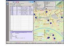
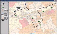
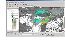 Our specific experience includes vehicle tracking / GPS integration systems,
real-time monitoring systems, various mapping applications (environmental, military,
telecommunications, forestry, transportation, statistics), GIS for emergency
services, GIS database design, data conversion, and online mapping applications.
Our specific experience includes vehicle tracking / GPS integration systems,
real-time monitoring systems, various mapping applications (environmental, military,
telecommunications, forestry, transportation, statistics), GIS for emergency
services, GIS database design, data conversion, and online mapping applications.
Please contact us for more information
about GIS and how it can improve your business.
|
 |